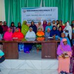
Experts in geospatial and public health fields on Wednesday gathered in Kano to mark the 2025 World GIS Day, focusing on the use of Geographic Information Systems (GIS) to strengthen global health equity and development planning.
The event, organised by eHealth Africa, featured the theme: “GIS for Global Health Health Equity: Embracing the Geo-Generalist Era” brought together innovators, health practitioners, researchers and development partners.
Mr Abdulhamid Yahaya, Deputy Director, Global Health Informatics at eHealth Africa, said the celebration showcased how GIS was transforming health intelligence and community resilience across Africa.
“We are celebrating the growing importance of geo-generalists and the role GIS plays in driving global health equity,” he said, adding that the forum enabled stakeholders to share insights on applying geospatial data to tackle health challenges.
The Director-General, Kano Geographic Information System (KANGIS), Dr Dalhatu Aliyu Sani, said GIS Day remained an annual forum for demonstrating the impact of geospatial tools in solving public health problems.
Aliyu-Sani, who presented a systematic review on the application of GIS in global health, noted that Africa ranked third globally in GIS-related public health publications.
He said Kano State had significantly improved its geospatial infrastructure since the re-establishment of KANGIS, following renewed investments in enterprise GIS and ICT systems.
“With improved systems, KANGIS now generates over N750 million monthly, compared to N50 million previously,” he said.
He added that the state had begun implementing its Spatial Data Infrastructure (SDI) to support sectors such as security, agriculture, health and other critical sectors.
“GIS is no longer just about land administration. It is about spatial data for planning, security, environmental monitoring and sustainable development,” he said.
Mr Oros-ghene Adia, Deputy Director and Technical Lead, CORE Group Partners Project, said GIS had played a transformative role in disease eradication and health service uptake, including polio and malaria interventions.
“GIS helps us understand where people live, where diseases occur, and how services can reach them more effectively. It has moved us from static paper maps to dynamic, data-driven decision-making,” he said.
He identified limited skills, infrastructure gaps, and data challenges as barriers to wider GIS adoption in Nigeria but expressed optimism that ongoing advocacy and innovation would close the gaps.
Similarly, Dr Esther Shupel-Ibrahim, Chief Scientific Officer at the National Space Research and Development Agency (NASRDA), said GIS and remote sensing remained indispensable for detecting, analysing and responding to health outbreaks.
“GIS helps pinpoint exactly where diseases occur and supports better planning and interventions,” she said, urging states to adopt modern geospatial tools, including AI and machine learning.
“If we continue to rely on traditional methods, we will struggle to address emerging challenges such as climate-driven health threats. GIS helps us predict, plan and act,” she said.
The event featured presentations, panel discussions and exhibitions showcasing geospatial innovations across health, security, agriculture and urban development.


